

Every point on our interactive map tells a story of environmental commitment. Through Life-Nitrazens, a project in which Ibercivis takes part, citizens in Spain and Portugal become the eyes and hands of science, using the technology of the Geonity App to monitor the health of our river basins and build transparent, participatory water governance.
The heartbeat of the map: thousands of samples to protect our water
The digital heart of Life-Nitrazens is a living open-data map, fed during this sample-collection phase. Our commitment is ambitious: to mobilise at least 2,500 citizens to collect and analyse 3,000 water samples (surface water, groundwater and tap water). This large participatory monitoring network covers a representative area of 34,435 km², linking the Duero and Ebro river basins in Spain (30,412 km²) with the Mondego basin in Portugal (4,013 km²).

Thanks to this collective effort, the project is filling critical gaps in environmental information on small water bodies and in rural areas that often fall outside official monitoring networks, democratising information and ensuring that the data are accessible to everyone. All this effort has resulted in almost 600 samples collected across dozens of measurement points in the Ebro and Duero basins during this first sampling phase, which has also laid the foundations of the citizen infrastructure of nodes, ambassadors and participants, who will keep collecting samples in the following stages of the campaign.
In addition, the data provided by citizens during these nitrate monitoring campaigns will be available on the Life-Nitrazens Data Exchange Platform being prepared by the project and in the federated data space that is also under construction, so that they can be consulted and also used in scientific research on nitrate pollution in our water bodies.
Geonity: Ibercivis technology that brings rigour to citizen science
How can we ensure that a sample taken by a neighbour in their village is scientifically valid? This is where Geonity comes in, the citizen science platform developed by Ibercivis, a partner in the project. This mobile app, already used in other projects of the foundation, has been specifically adapted for Life-Nitrazens to guide volunteers step by step in a simple and intuitive way.
On reaching a water point, participants use Geonity to:
- Geolocate the sample with precise GPS coordinates. To protect privacy on the public map, the system blurs private points (such as wells or household taps), showing only an approximate area.
- Record key metadata such as the type of water (tap, well, canal or river), the date, the exact time of collection and the weather conditions at that moment.
- Upload photographs of the surroundings that provide visual context to facilitate scientific analysis and validation of the sample.
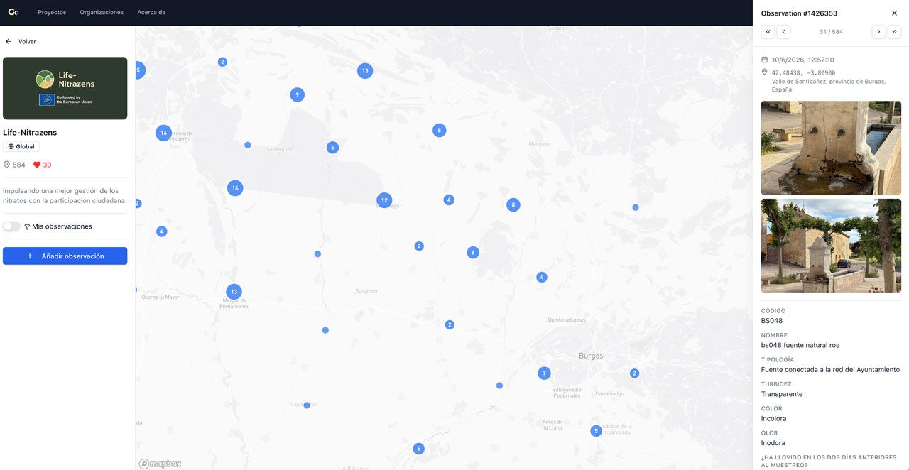
Even if participants are in a natural area with no mobile coverage, the app stores all the data locally and sends it automatically to the server as soon as the internet connection is restored. This digital record is essential: the quality control protocol requires every bottle delivered to be linked to its metadata on the platform, so that laboratories can process it and the traceability of the sample is guaranteed.
How our campaigns are designed: a cyclical and rigorous roadmap
To ensure that the data reflect the temporal and seasonal changes in water, the project is structured around three major sampling campaigns of five months each:
- Campaign 1: April to August 2026, just concluded, with excellent participation figures.
- Campaign 2: October 2026 to February 2027.
- Campaign 3: April to August 2027.
Each of these campaigns follows a rigorous operating cycle divided into five phases that repeat in an orderly way:
- Phase I – Setting up the Network: The physical collection Nodes are activated and the local Ambassadors, who energise the volunteer community, are trained.
- Phase II – Preparing the mini-campaigns: Short, time-limited windows of a few days to optimise logistics, define the sampling points and hand out the science kits (bottles, labels and thermal bags) to volunteers.
- Phase III – Field sampling: The big day of fieldwork. Volunteers rinse the bottle three times beforehand with water from the sampling point itself to remove impurities, fill the container avoiding air bubbles and place it in the insulated bag, protected from the heat. Time is critical: the sample must be delivered to its reference Node within a maximum of 3 hours to prevent the nitrates from changing chemically.
- Phase IV – Logistics and laboratory analysis: Samples are refrigerated immediately at the Nodes and transported weekly under strict cold-chain conditions to the reference laboratories: the University of Burgos (UBU) for the Duero basin, CITA-Aragón for the Ebro basin, and the University of Coimbra together with Aguas do Centro Litoral for the Mondego basin. There, the exact nitrate concentration (in mg/L) is analysed with technical precision.
- Phase V – Data validation and transparency: Before publication, the analytical results are checked and validated by cross-referencing the laboratory data with the metadata recorded by the participant in the app and with the Nodes’ control sheets. Once validated and their quality guaranteed, they are integrated into the Life-Nitrazens Data Exchange Platform (developed by Osoigo) for open viewing and public download under the Open Science model.
Our sincere thanks to our community
None of this would be possible without the extraordinary social fabric that sustains the project. At Ibercivis, as a partner in Life-Nitrazens, we want to thank each of the Ambassadors for being the social driving force in their rural communities. We thank the local Nodes (town councils, civic centres and associations) for generously lending their spaces and safeguarding the samples. And, of course, we thank every participant who has decided to spend their time collecting water so that their effort becomes scientific knowledge.
Thanks to all of you, we are building a collective tool that protects public health, safeguards our ecosystems and guides administrations towards fairer and more effective water policies.

Join the change: take part in the upcoming campaigns
Do you want to know what water runs through your nearest tap, well or river? Do you want your commitment to become useful data that protects your territory? The LIFE-NITRAZENS Local Support Network is still very much alive and always open to new hands.
It doesn’t matter if you didn’t take part in the earlier phases; every new mini-campaign is a chance to start from scratch. Sign up through our official form and we will assign you to your nearest Node, welcoming you to our active WhatsApp community so that you receive your science kit and all the training you need.
Sign up here to take part as a volunteer or ambassador.